hutchins_appe
 hutchins Apendix Index
ARCHEOLOGICAL ASSOCIATES, INC.
Cultural Resource Specialists
PO BOX 81 PUTNEY, VERMONT 05346
| ĀMr. Sean James, P.E. | ĀRE: | ĀArcheological Resource Assessment |
| ĀHoyle Tanner & Assoc., Inc. | Ā | ĀMontgomery BHO 1448 (23) |
| Ā150 Dow Street | Ā | ĀHutchins Covered Bridge Renovations |
| ĀManchester, NH 03101 | Ā | ĀTown of Fairfield, Franklin County, VT |
Dear Sean,
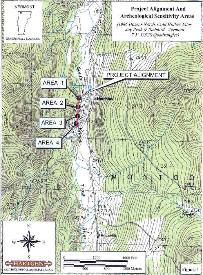
Hartgen Archeological Associates, Inc. (HAA, Inc.) recently completed a site visit and conducted research for an Archeological Resource Assessment (ARA) for the proposed Hutchins Covered Bridge (Montgomery BHO 1448(23)) Renovation project in the Village of Montgomery Center, Franklin County, Vermont. The Hutchins Covered Bridge, which is listed on the National Register of Historic Places, is constructed over the Trout River, and is located on Soden Road (Town Highways 27 and 40)just off of Vermont State Route 118 (Figure 1). The Hutchins Covered Bridge Renovations will entail the construction of a temporary detour road which will start at the southwest corner of the bridge. The proposed detour road will measure approximately 112 mile in length, and will connect TH 40 with TH 33 (Gibou Road) to the south. The Area of Potential Effect (APE) for the proposed bridge project encompasses the area from the southwest corner ofthe bridge along the route of the proposed detour road.
An assessment and sensitivity determination for work on the bridge, and the immediate vicinity of the bridge crossing (for the possible location of a temporary bridge) has already been conducted by Vermont Agency of Transportation (Vtrans) archeologist, Jen Russell (Agency of Transportation Memo, January 12, 1999). Ms. Russell determined that there were archeological remains associated with the historic Hutchins mill on the northwest side of the bridge. The river bank directly south of the bridge was not considered sensitive for significant archeological resources. At this time, it was recommended that if a temporary bridge were necessary, that it should be constructed on the south side ofthe bridge. These previous determinations for the bridge project were agreed to by Scott Dillon from the Vermont Division for Historic Preservation (VDHP), to which Emily Wadhams, State Historic Preservation Officer (SHPO) at VDHP, concurred. All proposed work associated directly with the historic Hutchins Covered Bridge has previously been conducted and cleared by all appropriate agencies.
 |
The Archeological Resource Assessment provides the information necessary to assess the potential for National Register Listed or Eligible archeological sites to be effected by the project. The ARA identifies potential areas of historic or precontact sensitivity. The research and report conforms to the guidelines for archeological studies under Section 106 of the National Historic Preservation Act, as defined by the Vermont Division for Historic Preservation (VDHP 2002), the Vermont Historic Preservation Act, and Act 250 (Peebles 1989). This letter report presents the results of the research and site visit. Site reconnaissance was conducted by HAA, Inc. archeologist on AprilS, 2006. The archeological report was written by project director, Elise Manning-Sterling and edited by principal investigator, Karen S. Hartgen. Graphics were prepared by Bruce B. Sterling.
Background Research
The archeological investigation entailed research into the historic and precontact use of the project vicinity and its environs and the investigation of the archeological site files. The literature review for historic and precontact sites consisted of:
- Research at the Vermont Division for Historic Preservation (VDHP) including:
- archeological site files for sites within or adjacent to the project area
- archeological surveys conducted on or near the project area town and environmental project files
- National Register listed archeological sites and standing structures located within or adjacent to the project area
- archeological sites being considered for the National Register,
- Research at the Vermont State Library and the Vermont Historical Society including:
- historic maps and
- review local histories of the project vicinity.
Precontact Sites and Sensitivity
Montgomery Center and the Hutchins Covered Bridge are located in the narrow Trout River valley in the Green Mountains, situated approximately seven miles (17.5 km) south of the Canadian Border. The terrain adjacent to the Trout River within the project area varies between low level river terraces, and slope leading up to rolling hills overlooking the river valley. A series of waterfalls are present at the southern end of the project area adjacent to Gibou Road.
Research at the VDHP revealed that there are no recorded archeological sites located within the project area or in the near vicinity. The closest archeological site is located in Avery Gore approximately four miles to the south, where it was reported that a large Indian burial ground was located. The dearth of recorded sites suggests that the area's use during precontact times was limited. However, there are other factors which would account for this phenomenon, including the paucity of archeological surveys conducted in this area, the presence of low density precontact sites and/or seasonal or intermittent camp sites which were not used intensively.
The VDHP predictive model form was used to determine the precontact sensitivity of the project area. An evaluation of the project area produced a rating of 32, indicating that the general area is considered archeologically sensitive. The areas of level to gently sloping terrain in terrain overlooking the Trout River and falls have the highest archeological sensitivity for the presence of precontact sites. Limited archeological testing would determine whether any intact archaeological resources are present in these areas.
Historic Archeological Sites and Sensitivity
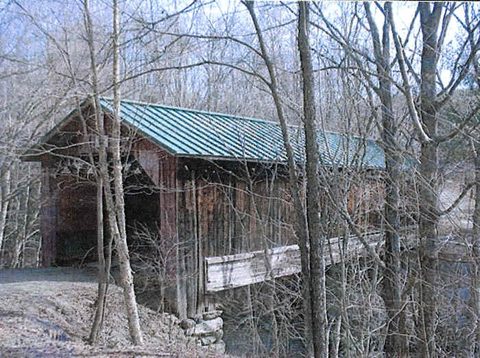
The background research revealed that no recorded archeological sites or cemeteries are located within the project area limits. The Hutchins Covered Bridge was built in 1883 by Sheldon and Savannah Jewett of Montgomery (photo 1). It is located on the South Branch of the Trout River, whose water power was utilized for the operation of various mills in during the 19th century. Stone walls and foundations associated with the Hutchins butter tub factory and sawmill, which was in operation from the mid-1800s to 1914, are present along the northwestern corner of the bridge. Southwest of the bridge, a stone foundation is evident which may either be associated with the mill, or may represent housing for mill workers, who were documented to have lived in mill houses on "Bazoo Road" located on the west side of Hutchins Bridge (Vtrans memo 1999).
 |
National Register Sites
The Hutchins Covered Bridge c. 1883 is listed on the National Register of Historic Places. The National Register nomination form notes that;
- The Hutchins Covered Bridge consists of a single span supported by two flanking timber Town lattice trusses. The structure has not been reinforced by any of the various devices added to many other covered bridges in Vermont. The bridge rests on abutments built of irregular stone blocks laid dry which stand on prominent outcrops of bedrock. The east abutment is almost completely formed by an overhanging outcrop, on top of which a few stone blocks have been laid to receive the ends of the trusses. The Hutchins Bridge is 77 feet long overall and 19.5 feet wide; it has a 16-foot roadway. The wood floor consists of planks laid flat both longitudinally and transversely to the trusses, overlaid with two longitudinal strips of planks for driving surfaces.
- Five other covered wood bridges remain in the Town of Montgomery, giving it the highest concentration of covered bridges by town in Vermont. Two brothers, Sheldon and Savannah Jewett of Montgomery, built all six of the bridges; they completed the Hutchins Bridge in 1883. The Jewetts used Town lattice trusses in all ofthe bridges, which also share common architectural design and similar dimensions (except for length). Together with another bridge constructed by the Jewett brothers across the Trout River in the adjoining town of Enos burg, the Montgomery bridges constitute the most extensive surviving record of the work of any individual covered bridge builders who practiced their trade in Vermont.
In 1995, a study was conducted for the Hutchins Covered Bridge by McFarland-Johnson, Inc. for the State of V ermont Agency of Transportation as part of a long-range plan for the preservation of historic covered bridges of Vermont (McFarland-Johnson, Inc.1995). To provide for the preservation of the Hutchins Bridge, this study recommended one of two options, which include the closing of the structure and the construction of an adjacent bypass, or the rehabilitation of the structure for moderate traffic.
Vermont State Register Site
There are four structures in the project vicinity which are listed on the Vermont State Register.
- The William Stiles-S. Gillis Residence c. 1865. A Vernacular Greek Revival used in conjunction with the Classic Cottage Type. The initial owner of the house was William Stiles, the owner of the prosperous Hutchins Butter Tub Factory. It is located east of the Covered Bridge, just west of Vermont Route 118.
- Kennett Residence (Mill Worker's House) c. 1890. Vernacular which is a typical, plain workers house commonly found near previous mill sites. It is located southeast of the Hutchins Covered Bridge, on the west side ofTH 43.
- Hutchins Mill Farm Inc c. 1870. A Vernacular Italianate structure. The tub factory owner, William Stiles may have owned the original portion of this house. It is located on top of the hill directly west of the Hutchins Covered Bridge.
- Barnaby Residence (Mill Worker's or Dairyman's House c. 1890. It is located on the west side of Gibou Road.
 Historic Maps and Sensitivity
 Joe Nelson, P.O Box 267, Jericho, VT 05465-0267
This file posted 03/10/2009
Joe Nelson, P.O Box 267, Jericho, VT 05465-0267
This file posted 03/10/2009